|
edit SideBar
|
Species / Aporrhais Bowerbankii
Stromboidea
Original Description of Scalaria bowerbankii by Morris, 1852:
- "Testa elongata, turrita, imperforata; anfractibus 9-10, ventricosis, rotundatis, suturis distinctis, longitudinaliter costatis; costis 18-20, subacutis, interstitiis transversim striatis; anfracto ultimo carinifero; apertura rotundata."
- "An elongated, turreted, rather thick shell, with nine to ten ventricose volutions, longitudinally costated; costae eighteen to twenty, somewhat acute, and slightly oblique, the ribs as well as intervening furrows transversely striated; the last volution carinated. The ribs on the lower volutions are sometimes divided and more irregular than on the upper ones."
Locus typicus: Herne Bay, Kent County, South East Region, England, UK
Stratum typicum: Thanet Beds, Paleocene
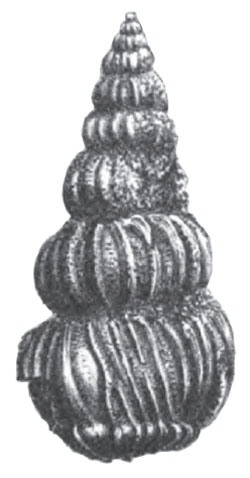
Scalaria bowerbankii Morris, 1852, pl. XVI, fig. 9
History and Synonymy
1871
Lyell, 1871, p. 269:
- "Thanet Sands (C.3 p. 252): The Woolwich or plastic clay above described may often be seen in the Hampshire basin in actual contact with the chalk, constituting in such places the lowest member of the British Eocene series. But at other points another formation of marine origin, characterised by a somewhat different assemlage of organic remains, has been shown by Mr. Prestwich to intervene between the chalk and the Woolwich series. For these beds he has proposed the name of "Thanet Sands", because they are well seen in the Isle of Thanet, in the northern part of Kent, and on the sea-coast between Herne Bay and the Reculvers, where they consist of sands with a few concretionary masses of sandstone, and contain, among other fossils, Pholydomya cuneata, Cyprina morrisii, Corbula longirostris, Scalaria Bowerbankii, etc. The greatest thickness of these beds is 90 feet."
1878
Ramsay, 1878, p. 239:
- "The Thanet Sand, absent in the Isle of Wight, is so named by Professor Prestwich because it is so well developed in the Isle of Thanet on the Thames. It lies at the base of the Eocene strata of England, and consists of fine, light-coloured, quartzose sands, partly mixed with clayey matter. It usually lies on a layer of Chalk flint, of an olive-green colour externally, and which probably represents the effect of the waste of the carbonate of lime of the chalk which was carried away in solution as bicarbonate, through the infiltration of rain-water after the deposition of the sands, the associated silica having been concentrated and deposited in this band. These sands range from the Isle of Thanet westward to the neighbourhood of London, varying from about 50 feet thick, in parts of Kent, to 4 feet, at East Horsley, where they disappear, being overlapped by the Woolwich and Reading beds. They are quite unknown in the Hampshire basin. The fossils of this subformation are entirely marine, and embrace about 70 known species. Among these are a shark of the genus Lamna, Pisodus, and others; a Nautilus; Gasteropoda, such as Fusus tuberosus, Scalaria Bowerbankii, Natica, Aporrhais, &c.; a considerable number of Lamellibranchiata, such as Nucula Thanetania, &c.; Pholadomya Koninckii &c.; Corbula, Cardium, Ostrea Bellovacina, &c. &c.; Crustacea, Hoploparia, and Palcśocorystes; spines of Echini (rare), a coral, a few Foraminifera, and land-plants. In the Paris basin, so celebrated for its Eocene strata, the Sables de Bracheux are the equivalents of the Thanet Sand, in which the skull of a carnivorous quadruped (Arotocyom primśvus) was found."
1884
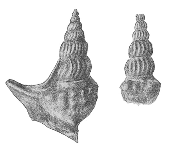
- Found in the Thanet Beds in Herne Bay, the largest measuring 16 mm (Gardner, 1884)
Aporrhais bowerbankii in Gardner, 1884, pl. XVII, fig. 9, 10
Etymology: named after Mr. Bowerbank, whose collection contained the types
References
- Gardner, 1884
- C. Lyell, 1871. The student's Elements of Geology, New York, Harper & Brothers, pp. i-xxiv, 1-640
- Morris, 1852, Quart. Journ. Geol. Soc. 1852, p. 266
- A.C. Ramsay, 1878. The physical Geology and Geography of Great Britain, A Manual of British Geology, London, Edward Stanford, 654 pp. Illustrated with a Geological Map of Great Britain and 115 Figures.
|